Posted
on September 15, 2017, 5:40 pm,
by QT Luong,
under Locations.
Mountaineering led me to photography and
rock climbing brought me to California. About twenty years ago, my friend from France visited me and we went climbing in Yosemite, tackling the classic “Central Pillar of Frenzy” on Middle Cathedral. Like many in Yosemite, that climb follows cracks in the rock. Instead of pulling on holds, you’d jam your fingers or hands in the cracks. The next day, both of my wrists hurt, and instead of climbing, we hiked. Back in the Bay Area, I was still in pain and saw a doctor. The diagnostic was devastating. I was told that I could not climb cracks again. The initial culprit wasn’t even rock climbing, rather improper keyboarding technique that had led over the years to repetitive stress injury (RSI), but climbing made it worse. For the next twenty years, I did not do a single multi-pitch rock climb.
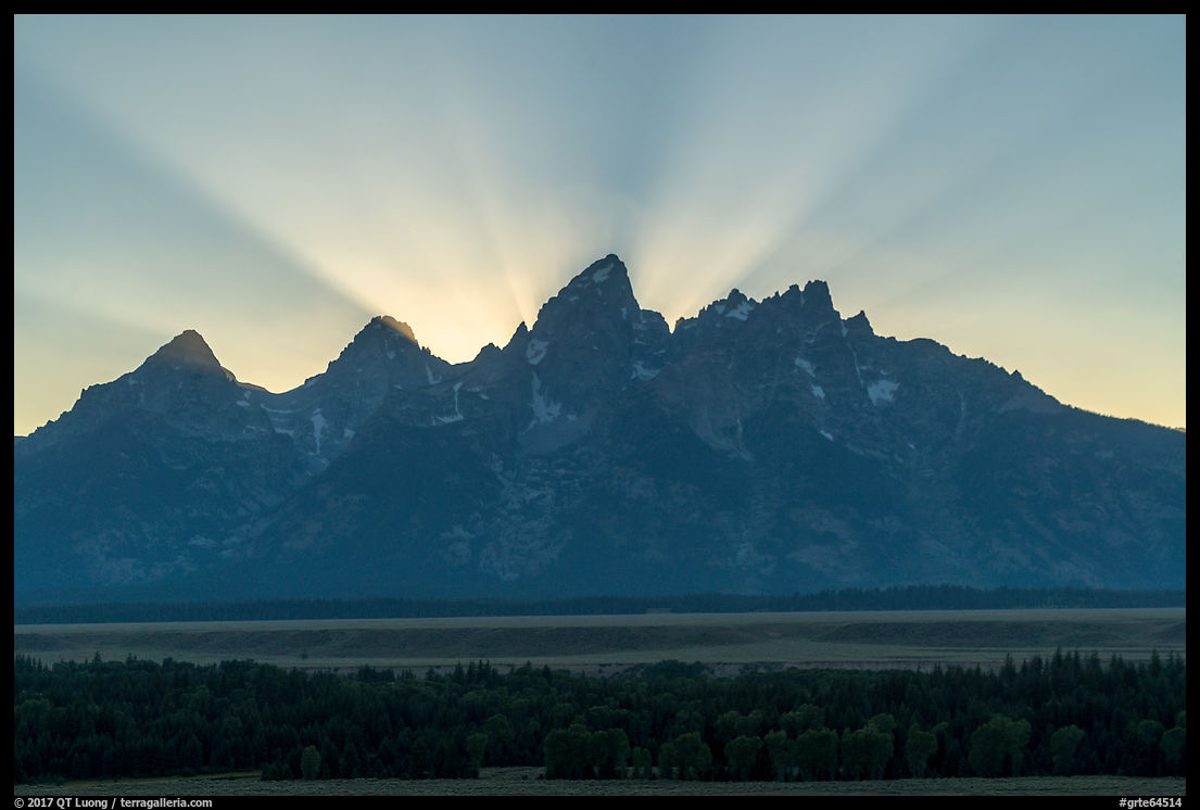
Contributing to keep me away from the rock, I married a self-described acrophobic and started a family. The forced retirement focussed my efforts on the national parks photography project. Over the next two decades, I would visit Grand Teton National Park five times, the average number of visits for each national park. Each time, I would photograph the striking Grand Teton peak from afar, as if the mountain now belonged to a different plane, within sighting distance, yet now inaccessible. As the years passed, I became more curious about what the view from the iconic summit would look like.
This year, as I was planning a
Grand Teton trip to view the eclipse with my brother-in-law Nhon, it occurred that since he’s become such a strong climber, even though we had never climbed together in the mountains, we could team up to climb the Grand Teton. If the world was going to end after the eclipse, at least I would have stood on the “Grand” before I died!
The Plan
The Grand Teton is one of the classics of American mountaineering. As can be guessed from its sharp profile, there is no hiking route to the summit. Even the two easiest and most popular routes, the Owen-Spalding and Upper Exum Ridge,
require technical rock climbing with ropes. We set our sights on the Direct Exum Ridge because the route, which combines the Lower Exum Ridge with the Upper Exum Ridge is listed in the historic book Fifty Classic Climbs of North America.
Since the 7,000 feet of elevation gain from the trailhead to the summit seemed to be a bit too much to handle round-trip in a single day, the first step was to secure a backcountry camping permit. Most of them are provided on a first-come, first served basis, and competition is fierce as only 18 people are allowed to camp at our preferred site, the Lower Saddle. When we showed up at 5:30 am at the Jenny Lake Ranger Station, 10 people were ahead of us, but by the time it opened, at 8 am, more than 50 were behind us. The process was efficient and we were happy to walk out permit in hand.
The Garnet Canyon Trail
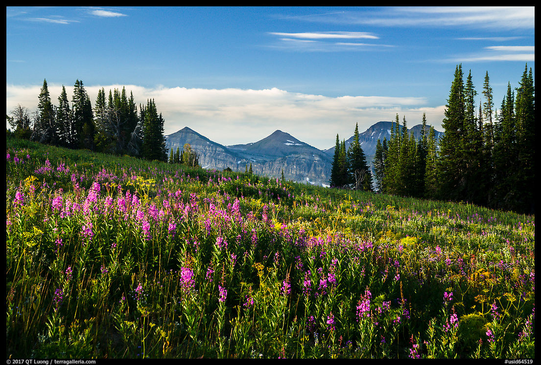
We started at the Lupine Meadows Trailhead (6,650 feet) in the early afternoon. From there, we followed the trail up Garnet Canyon for 5,000 feet elevation gain in 7 miles. Since it is such a steep hike, I didn’t expect it to be that popular, but when the views opened up above the forest, I began to see why it was the case. The scenery along the trail was rewarding in itself and with such an elevation gain, the scenery changed from forest, to subalpine meadows, then rocky terrain with glaciers. As the impressive peaks got closer, we were grateful to be able to easily refill bottles with the sweet water of the cascading mountain stream. From Jackson Hole, the mountains are only a backdrop, but on the trail, they are surrounding you. I felt I was coming home.
The last photo is of Chris and Aleksandra completing a single-day ascent and descend of the Grand. I had climbed with Chris two decades ago while he was working at Stanford on the first of his two PhDs. I had not seen him since, but he invited us to a prized campsite in the park around the eclipse time (Thanks!), for which he started planning seven years ago. Fittingly, our reunion was below the Lower Saddle. A few days later, Chris and Aleksandra would be back on the Grand to view the eclipse.
The Lower Saddle Camp
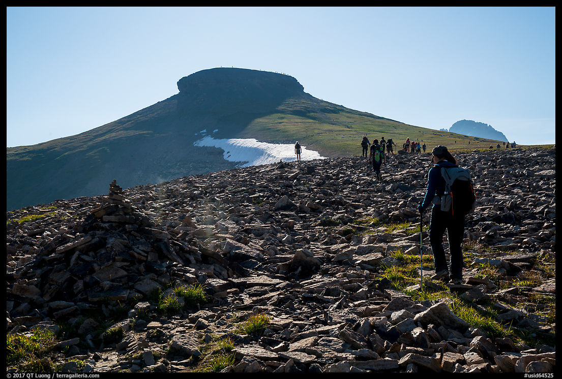
Our objective for the afternoon was the Lower Saddle (11,650 Feet), which is the pass between Middle Teton (12,805 feet) and Grand Teton (13,776 feet), and the highest campsite that can be used to climb the Grand Teton. Besides the superlative views both on the Wyoming and Idaho side at sunset, we had a good look at our route for the next day, which follows the prominent ridge in the center of the Grand Teton. I felt a mixture of apprehension and anticipation. Winds can be howling at the Lower Saddle, so we were glad to have found a campsite protected by rock piles.
The sunrise
We set up the alarm for 4 am and started towards the mountain, made more mysterious by the night. While scrambling in the dark resulted in some wandering off-route into unstable talus – and a bit of cursing when the slopes gave way underfoot, it was wonderful to witness the arrival of the dawn and sun during the approach to the climb. At such high elevations, the alpenglow takes on a magical quality that I had missed by watching from below on all those years. I could now clearly grasp the structure of the mountains from a high perspective. Because it was a demanding climb for me, I had taken only a 24-70mm lens. In retrospect, the 16-35mm might have been a better choice, but multi-image panoramas worked fine for the scenery. The camera was the mirorless Sony A7R2, and that was one time when I fully appreciated its smaller size and lighter weight compared to the DSLRs!
The Exum Ridge climb
We roped up at sunrise. The route turned out to offer excellent climbing, with the sheer walls more intimidating than difficult thanks to positive holds. It had been two decades since I climbed with a pack on my back and I was glad to be following. The sun did not visit us until the junction with the Upper Exum route, and the wind contributed the chill. Although it might sound unpleasant, I relished the memories brought by having fingers numbed by the cold to the point of not feeling the rock. I tried to warm them up with my breath. I was elated by the exposure and the privilege of being in a place where man normally doesn’t belong. After completing the difficult climbing parts of the route, we coiled the rope so that we could move faster towards the summit – which is always further than one thinks.
The higher we got, the better the view, as seas of peaks began to unfold. However, this doesn’t necessarily translate to more compelling pictures, and in the hazy midday, I hardly felt like photographing from the summit. It is so difficult to succeed as a mountaineer and a photographer at the same time! However, even if the images from lower are better, it is eventually the experience and memories that make it worth the effort. Although I slowed down our party by running out of gas on the hike down the Garnet Canyon Trail – we would not return to the Lupine Meadows Trailhead until midnight -, I was happy to be able to steer my aging body towards a bit of youth.
As with the eclipse, the top remains etched in my mind and I know that I will not look at the mountain the same way as I did before the climb.
Posted
on August 28, 2017, 1:07 pm,
by QT Luong,
under Locations.
Summary: For the total solar eclipse of August 21, 2017 in Grand Teton National Park I chose a backcountry location discovered by William Henry Jackson. My shooting plan to capture this iconic shot did not involve straight photography, but rather a timelapse and a 360-degrees panorama.
Attending or not attending ? That is the question
I am a landscape photographer. Without the connection to the land,
photographing a celestial event doesn’t get me that excited. Don’t get me wrong, I understand the difficulty and admire well-crafted close-ups of celestial objects. However, those astronomy pictures lack the sense of “being there” which defines most of my work. They could have been made in a wide range of locations – and are best shot with telescopes. Tens of millions were expected to see the 2017 eclipse, the
most accessible ever in America during our lifetime, and therefore the most viewed ever. Most of their successful close-up images would be similar, whereas I am striving for the distinctive.
The last total eclipse in America happened 38 years ago. The next best thing to a total eclipse is an annular eclipse, which occurred in May 2012 in America. To photograph it, I traveled to West Texas because the sun would be low on the horizon at eclipse time
(story and photos here).
When I learned of the 2017 eclipse, I was initially disappointed that it would happen at
midday in summer. The sun would be overhead, high above terrestrial features. To include both the sun and the
landscape, one would have to use a very wide-angle lens, which would make the sun tiny in the picture.
I initially thought about sitting this one out. But I read that a total eclipse is something else, to which a partial eclipse barely compares, and this made me curious.
Even if I would not come back with a great picture, I’d be able to witness a total eclipse with my own eyes without having to travel
to the ends of the earth. Sometimes, the experience must supersede the photograph.
The most spectacular location ?
Since the eclipse is a natural event, I wanted to experience its power
in the midst of a pristine landscape rather than in the city. Looking
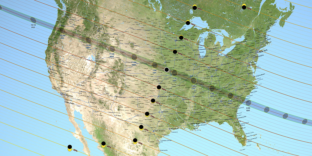
at the coast-to-coast 70-mile wide path, there were a number of national parks
traversed. However, it was pretty clear to me that the most spectacular
location would be Grand Teton National Park, home to one of
the most striking mountains – if not the most striking – in the country. Would you agree?
This sit well with me, since I am mostly known as a national parks photographer, and many readers have asked me for a followup to
Treasured Lands. Experiencing a spectacular natural event at a spectacular location appealed to others as well. If monetary value is an indicator of desirability for a location, note that the Washington Post article Airfares
to solar eclipse destinations soar to astronomical levels mentions
Jackson WY as the airport topping the charts of overpriced flights.
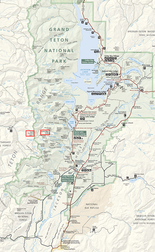
Pursuing the iconic shot
Map of Grand Teton National Park. In red boxes: Grand Teton and Table Mountain. All front country areas are east of the Teton Range.
There was just was a slight problem. Standing in any of the park’s
easy-to-access front country areas, the Tetons would be west of you, but at the
11:36 am totality time, the sun would be coming from the Southeast
(133.3 degrees azimuth). To me, choosing Grand Teton National Park to photograph the eclipse and not including the Grand Teton in the picture meant missing what would be a defining shot.
Others recognized that this was the iconic shot of the event. Astrophotographer Alan Dyer, in his
excellent 296-page ebook How to Photograph the Solar Eclipse
presciently writes “How many hours will it be after the eclipse before
images like this begin to pepper the internet, garnering thousands of
hits and likes”. The image in question was a composite of a large sun
in the western sky over the Grand Tetons superimposed with a
wide-angle image taken from the Wyoming side. What I didn’t expect was that despite their usually strict standards, even the venerable National Geographic didn’t resist the temptation, displaying on their Instagram an image even more outrageous than Alan Dyer’s example of what not to do (see image and read commentary on the controversy).
Although I strive for truthfulness, I admit having done my share of digital alterations. However, I’ve always tried to honor reality by not publishing such images of something that could never exist, even if labeled as “photo illustration”. Nature photographs derive much of their power from the assumed connection with reality.
Following the footsteps of William Henry Jackson
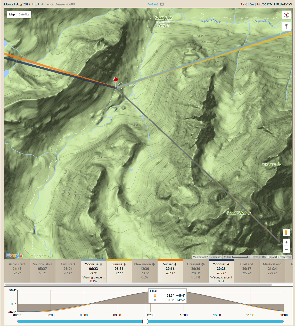
In this case, the solution to the problem was pretty simple: find a backcountry location northwest of the Grand Teton to photograph from.
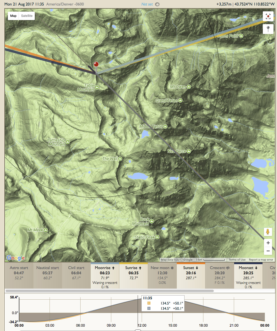
Photographer’s Ephemeris screenshot with South Fork position aligning sun and Grand Teton
Tracing the position of the Grand Teton at a 133.3 degrees azimuth with the Photographer’s Ephemeris
yields a location on a trail in the South Fork of Cascade Canyon. The
hike from the South String Lake Trailhead is 13 miles RT and only 1,700 feet elevation gain. However,
having been at Cascade Canyon Forks before, I remembered that from that location the shape of
the Tetons appeared quite distorted and indistinct because you are
standing so close and low. This was confirmed by a
photo from my friend Mike Cavaroc, a nature photographer and hiker living near the Tetons. In addition, the position in a deep canyon would not provide any view of the horizon. I had read that the sight of the land from a mountain top was special during an eclipse, and was as interested in the light on the land as in observing the sky.
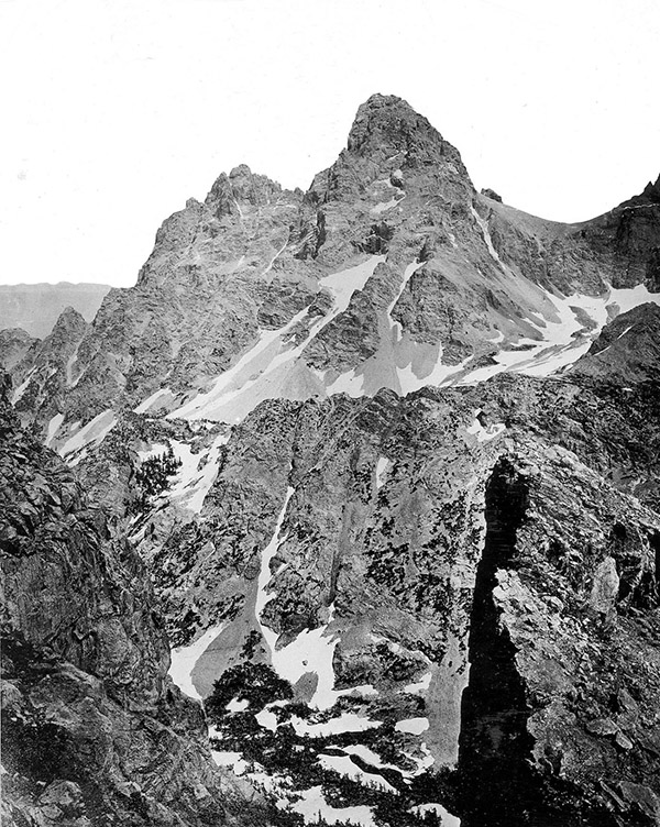
Grand Teton by William Henry Jackson, 1872
I looked for a higher vantage point on the west side of the Tetons that would preserve its iconic shape and allow a view of the horizon. The flat-topped,
11,106-foot peak called Table Mountain sits just at the border of
Grand Teton National Park. Although nowadays the immense majority of photographs of the
Tetons are from its Wyoming side, the first ever photographs of the Tetons were made from Table Mountain in 1872. Or more precisely from near Table Mountain. The photographer was none other than William Henry Jackson, whose photographs were instrumental in establishing
Yellowstone National Park, and on that occasion he and his party happened to have made the first ascent of Table Mountain.
Talk about standing on the shoulders of giants!
Read about Jackson’s efforts.
The only reason why the view isn’t photographed more often is that
the effort to reach Table Mountain, from the Teton Canyon Trailhead, is even more substantial
than to reach the South Fork, since it involves a 11.5-mile RT hike with 4,000
feet of elevation gain. But if Jackson did it in the 19th century, is it too much to ask of us, with our modern outdoor equipment and lightweight cameras, to hike the mountain?
Pinpointing the backcountry location
Although William Henry Jackson benefited from a “tabula rasa” (pun intended), because nowadays there is a trail to the summit of Table Mountain,
all the modern photos of the area tend to be taken from that summit. Such are the effects of a beaten path. While sitting at home planning for the trip, I thought I could find a better location.
First, looking at the published photos from Table Mountain, I noticed a foreground
with a slope and snowfield that I found distracting. I much prefer a view that shows the
full height of the mountain from its base in the South Fork to a truncated one. So did William Henry Jackson.
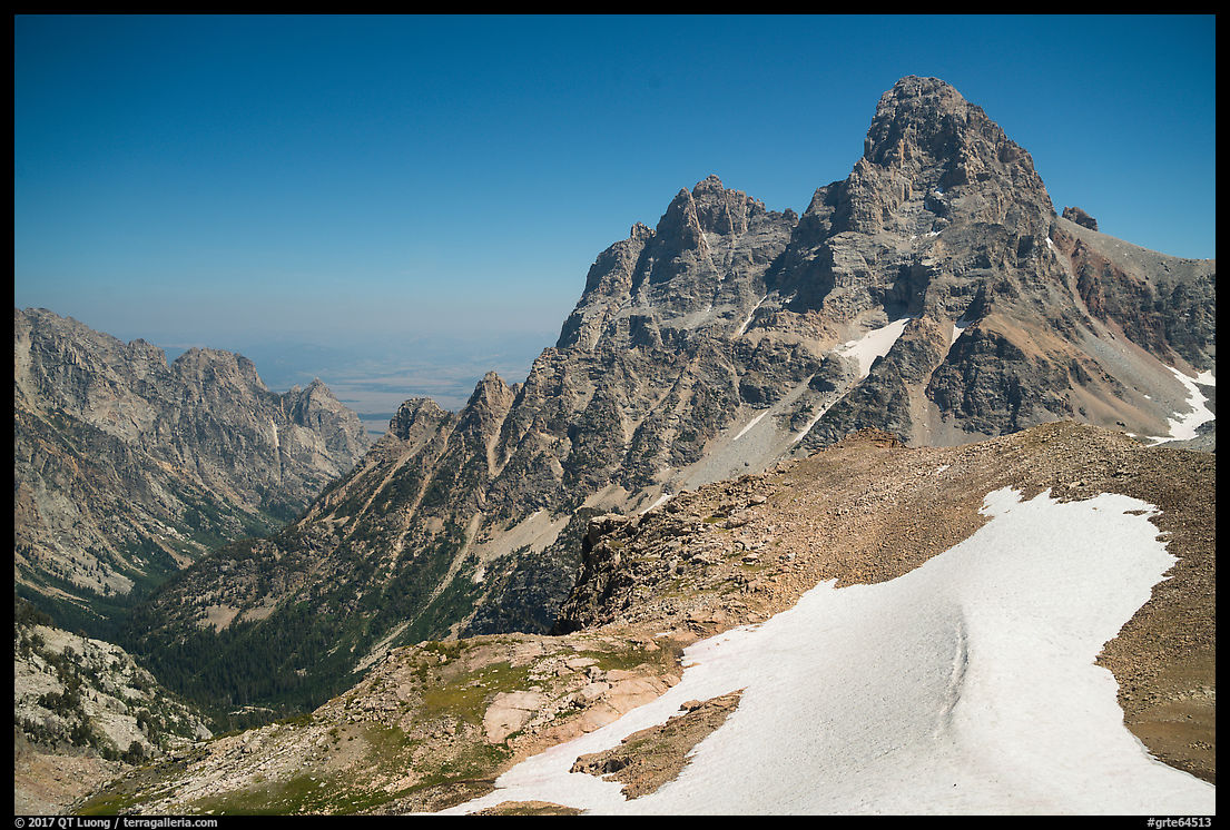
Tetons from the top of Table Mountain
Second, using the Photographer’s Ephemeris, I determined that if shooting from the Table Mountain, the sun would be placed right of
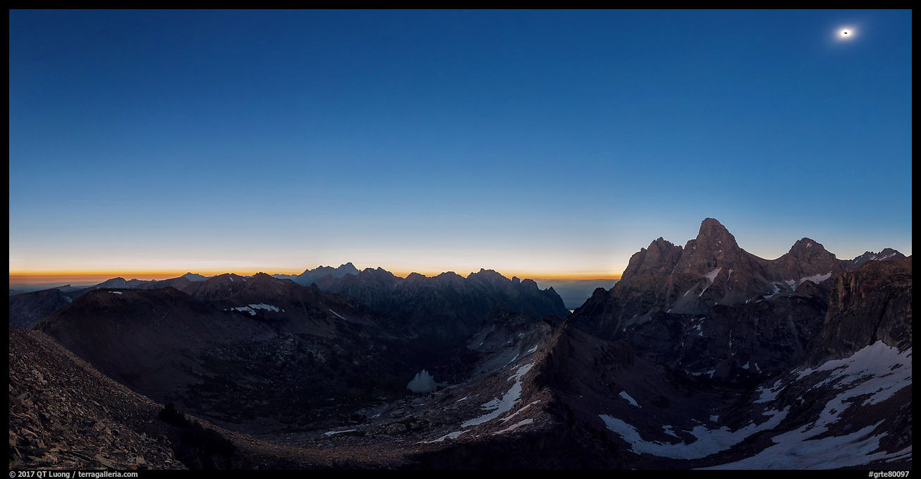
the Middle Teton. Centering the sun a bit better called for moving north on a ridge adjacent to the summit. While the excursion looked good on the map, I wasn’t sure of the exact nature of the terrain. It so happened that I had the perfect opportunity for reconnaissance, as exactly two days before our hike up Table Mountain, my brother-in-law and I climbed the Grand Teton. We were able to confirm visually what the map had indicated, and pinpoint the particular spot on the ridge were we wanted to be, just before a sharp drop.
Photographer’s Ephemeris screenshot with sun direction from ridge north of Table Mountain
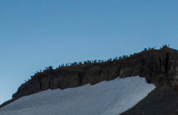
A third reason for not shooting from the summit is that Mike Cavaroc had warned me of possible overcrowding at the summit – not a good situation for photographing a 360 pano, let alone commune with nature. It turned out he was right. A headcount on Table Mountain accounted for about 250 people and 7 dogs. This is illustrated by the following crop from my 360 panorama. The distance from my viewpoint to Table Moutain was nearly half a mile. This short distance made a big difference. Don’t settle for the obvious location!
Table Mountain summit during eclipse, crop from 360 panorama
A Non-Photography Shooting Plan
The totality lasts about two minutes, but it represents the crux of the experience.
Since this was my first total eclipse, I didn’t want to spend that time looking at an electronic screen. But I still sought to capture as much of the experience as possible. Although I carried a medium telephoto zoom (70-300mm) and a square filter
made of Baader Astro solar film, I mostly planned to set up a pair of Sony A7R2 with wide-angle lenses and no filter.
The first camera would run a timelapse to capture all the temporal extent, starting from five minutes before totality to five minutes after totality, at the shortest possible interval of one second. A longer time span than the 12 minutes wouldn’t be that useful because the variation in light is rather slow farther from totality, and extended shooting of the sun without a filter isn’t the wisest thing to do. As calculated at home, framing both the sun at an elevation of 49 degrees and the Tetons in the horizontal orientation needed for video required using the 16-35mm f/4 lens at 16mm. That camera would run basically unattended once the timelapse was started.
I would use the second camera to create a high-resolution 360-degree panorama during totality to capture the spatial extent (technique explained here), and in particular as much as possible of the eerie light and 360-degree sunset-like glow that happens at totality. Since I’d forgo the time-consuming nadir, this would require me to shoot 12 frames at 14mm, which would take most of the two minutes, but since I am using a rotator with click stops, I would not have to look via the finder at any time, and could instead keep my eyes directly on the sun, sky, and landscape.
I deliberately renounced trying to make single still photographs but was hoping to be able to extract them either from the timelapse frames, or from the 360 panorama, which is about 27,000 pixels wide by 13,500 pixels high. This is quite a bit more than the trendy 360 video captures and could be used to make prints of tremendous quality. Let see how this turned out.
Eclipse day
On August 21st, it was a bit tough to wake up at a 2:30am, since the day before we had gone to bed past 1:00am after descending from the Grand Teton. My brother-in-law, sister-in-law, and I drove for two hours
from the Colter Bay Campground in Grand Teton National Park to the Teton Canyon Trailhead. Even that early in the morning, motorists were already staking out pullouts. At 5:00am, more than a hundred cars were already at the dusty Teton Canyon Trailhead. Fortunately, two deputies were there to make parking an orderly process. We began the steep ascent via the Face Trail and soon were hiking in T-shirts despite the early hours.
Late summer wildflowers on Trail to Table Mountain
The trail turned out to be spectacular, and worth hiking even without the final view of the Tetons and the eclipse. Even when the destination is the greatest, the journey can be its own reward.
Approaching Table Mountain
We bypassed the Table Mountain summit
and headed directly to the ridge. However, arriving at about 10am, we found the spot occupied by
a photographer who had camped there the night before to make sure he got it. If you have a good idea, you won’t be the only one! In order not to get in his view – and not having him in ours, we had to scramble down the ridge, which meant that I’d miss parts of the horizon in my 360-degree pano. Yet, I was able to capture more than 180 degrees of horizon. Even on the busiest day in the history of Grand Teton National Park, we secured a spot with no one else is sight for half a mile.
I had brought only one cable release, which doubles as an interval
timer for timelapse. At the last minute, I thought that if I used it
on my 360-degree camera, I would’t have to engage the self-timer as I
normally do in order to avoid vibration from pressing the
shutter. With 12 frames, and a 2-second self-timer (I normally
prefer 5 seconds), the time savings would amount to 24 seconds, almost
one quarter of the totality. Not something to be scoffed at! With the same goal, for the panorama camera, I kept a relatively short shutter speed of 0.5s, and this would also prevent the sun would not be blurred as it moved. Since I had to stop down the lens a bit for depth of field, this resulted in a ISO of 800. I am not sure what is the exact value of the f-stop, since the lens, an adapted Nikon 14-24mm, does not transmit metadata to the Sony camera.
This was possible because Sony cameras support a downloadable timelapse app that I could use to run the timelapse.
I did a short test run of the app, and it appeared to work fine. Since I was anticipating the exposure
at totality to be around ISO 100 f/4 4s, I set up the lens wide open and the ISO at 400. At five minutes
before totality, this resulted in a shutter speed of 1/400s. I anticipated that the shutter speed would slow down to 1s at totality,
which was the longest possible shutter speed that would not disturb the timelapse interval spacing.
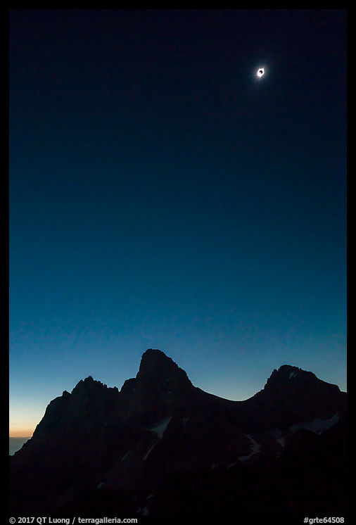
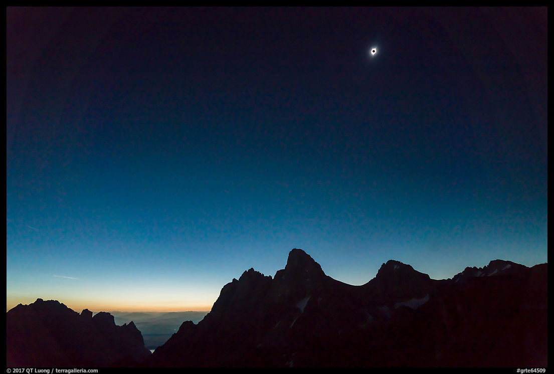
The totality came, and it was awesome. Having seen before the northern
lights and erupting volcanoes, I can confirm that it is the most
awesome spectacle in nature. And having witnessed a partial eclipse before, I can now
say with confidence that it doesn’t even remotely approach the experience of totality. This is one occasion where I did not expect pictures to do justice to the beauty and strangeness of the experience.
The results
The 360 degrees panorama turned out to be quite difficult to assemble, due to the variation in brightness during the eclipse, and the fact that it was shot near a mountaintop. I am grateful to Jordi Navarro Isern of Spain for his expertise in putting it together.
Tetons and horizon during eclipse, crop from 360 panorama (larger image)
As I was starting to shoot that 360 panorama at totality, although engrossed in
the moment, I couldn’t help notice that the shutter sound of the timelapse
camera was odd. It didn’t seem to slow down any bit. Shortly after the eclipse, a quick review confirmed my
suspicion. Although the letter “A” was displayed, the camera app had
acted as if the exposure mode was manual, and the shutter had remained
at 1/400s for the whole sequence, which represented an underexposure
of 8 f/stops! In the past, I had used the timelapse app before, but not in variable light.
Here is the raw, uncorrected time-lapse where the constant exposure captured the dramatic changes in light. (YouTube Link)
I do not know about lower in the Valley, but at 11,000 feet, it actually didn’t get dark like it did in the video, but rather like a twilight just a bit darker than the 360 panorama, maybe like 30 to 40 minutes after sunset. I noticed only one star – visible on the interactive VR 360 degrees panorama. A few years earlier, shooting with Canon cameras would have meant those frames would remain dark because brightening them would result in much noise. The combination of capabilities of the Sony sensors and Lightroom processing made it possible to salvage those shots with little effort:
Here is the result of applying the following settings: Exposure +5, Shadows + 50, Luminance noise + 70, Color noise + 100. I will post a corrected video later as well.
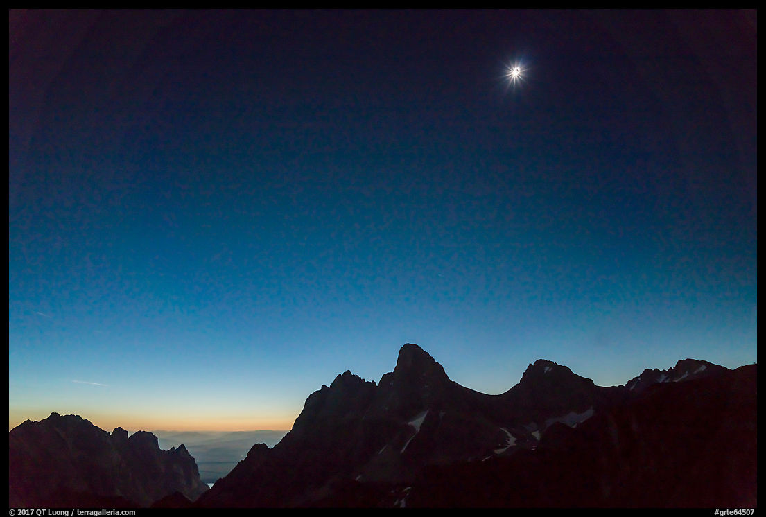
Beginning of totality
Diamond ring
Totality
Fortunately, my mistake did little to mar an awesome experience, and I am grateful that modern camera technology is so forgiving! Besides practicing and rehearsing in similar conditions before such a rare event, there are few things I would have planed differently. As for the execution of the 360 panorama,
next time, I will consider either automating it with a Gigapan or simplifying the capture by shooting a 15mm fish-eye on a single row. This will allow me to attend even more cameras, and maybe tackle the close-ups, although they are not my primary goal. The whole experience left me totally in awe, and you will see me again under the shadow of the moon. I hope that this long write-up has inspired you to plan your own future eclipse trips.
Posted
on August 24, 2017, 1:06 pm,
by QT Luong,
under Announcements.
After a well-received exhibit in San Jose, and a summer of productive travels, this fall I will continue to present my work in the San Francisco Bay Area.
All the presentations are about my project to photograph the national parks, and include an illustrated lecture (aka “slide-show”), a Q&A session, and a book signing for Treasured Lands. Copies will be available for purchase if you don’t have your own yet.
The presentations are hosted by various groups, however they are all open to everybody and are free. Here is what has been scheduled up to October, with more to come in the fall.
Gallery Director Genevieve Hastings introduces lecture at Art Ark, June 2017
Sunnyvale Photographic Club
Monday August 28, 7:30 PM
Murphy Park Recreation Bldg
250 N Sunnyvale Ave., Sunnyvale,
More info
Palo Alto Camera Club
Wednesday, September 20, 7:00 PM
Palo Alto Art Center
1313 Newell Rd, Palo Alto
More info
Sierra Club Santa Cruz Group
Thursday, September 21, 2017 – 7:00 PM
The Live Oak (Green) Grange Hall
1900 17th Ave, Santa Cruz
More info
Light and Shadow Camera Club
Tuesday, October 10, 7:00 PM
Church of the Nazarene
2575 Coit Drive, San Jose
More info
I’ll be delighted to meet you on one of those occasions!
Posted
on August 20, 2017, 5:48 am,
by QT Luong,
under Locations.
While the scenery of lakes and North Woods is beautiful, locations within Voyageurs National Park tend to look undistinguished. However, I have a clear favorite: Anderson Bay, which maybe has the most beautiful and varied short trail in the park and includes the best view in the park.
View from the top of the cliffs
Most of the views in the park are at water level since the heavily forested land has little elevation. Elevated views are rare and in general obscured by forest. After a half an hour hike from the boat landing, you’ll find what could be the most spectacular view in the park, as you stand on the top of white granite cliffs that abruptly rise 80 feet from the water, overlooking Anderson Bay dotted with islets typical of the North Woods.
The main view is facing East, and the scene works well as a silhouette at sunrise. In the autumn, the sun rises directly above the bay, whereas in the summer, it rises further left, behind a ridge, which isn’t as good. Looking towards the West, there is also a lovely view of the Anderson Bay.
The main view becomes front-lit at midday. On my first visit, in autumn, my most successful photograph was made in the even light of dusk, when the daylight-balanced film recorded blue tints. I aligned a group of nearby trees with two tree-covered islets to create a photograph with rhythm. Notice how some trees have changed in the interleaving two decades.
Rainy Lake
Continuing further the trail (counterclockwise), you reach the rock-lined shore of Rainy Lake, the largest in the park, near the Anderson West campsite, a good base for exploring the area. The trail hugs the shore closely, and you can easily wander on the rock slabs, which feature some of the oldest exposed rocks on earth. They are half the age of the Earth (2.8 billion year), and even older than those in the Grand Canyon. The light there is best early or late in the day.
Before leaving Rainy Lake, you arrive at beautiful Windmill Rock Cove, near the Windmill Rock Campsite. I preferred the mood of the cloudy weather of my first visit to the sunny weather of my second visit.
Beaver Ponds
While the trail it is well marked with cairns, it is lightly used and requires a bit of attention to follow. Shortly before the end of the loop, the trail overlooks a beautifully textured beaver pond which is best photographed in soft light. Beavers are important agents of change, as they rearrange the landscape by building dams, and Voyageurs National Park is a great place to observe the American beaver.
The Anderson Bay Loop Trail is about 1.75 mile-long. It is accessed from the landing dock by a 0.25-mile spur trail. To see another beaver pond, instead of returning to the landing, you can continue on the right fork on the trail towards Peary Lake, which is start of the Cruiser Lake Trail.
Logistics
The Anderson Bay Loop could be reached via the Cruiser Lake Trail system (9.5 miles one-way) that crosses the Kabetogama Peninsula from Kabetogama Lake. However, by far, the easiest way to get there is by boat.
You’ll need your own, since the location is not visited by the tour boats, and that is reason enough to rent one. With a large boat, you need to start on Rainy Lake, whereas boats smaller than 21 feet can be portaged from Namakan Lake at Kettle Falls, allowing you to start in Kabetogama or Crane Lake. At the back of Anderson Bay, you’ll find a large dock and a day use area with picnic tables and a toilet, and for camping, you can stay at one of the two sites previously mentioned.
Posted
on August 12, 2017, 6:46 pm,
by QT Luong,
under Locations.
Voyageurs National Park may sound more difficult to visit than the other national parks because you are traveling by water, but this is what makes your experience there unique. After reading my tips for getting on the water – based on my three visits to Voyageurs National Park – you’ll see that driving a boat through Voyageurs National Park is quite simple.
While it is possible to catch a glimpse of Voyageurs National Park from the road (see descriptions for Ash River and Kabetogama), to really see it you must get on the water. The National Park Service (NPS) organizes a few tours, there are water taxis and shuttles, but to have more freedom to explore, look for wildlife, and to carry all your gear easily, it is preferable to have your own boat. Boats there are like cars in other parks, and most of the time you’ll prefer to have your own, right?
Despite the fact that most of the park cannot be reached by road, Voyageurs National Park is not considered a wilderness. Rather most of the destinations within are classified by the NPS as frontcountry, with the distinction that you reach them by boat rather than by car. You’ll see many other boats, especially in summer. While this limits the solitude, it will be reassuring if you don’t have prior boating experience.
Understanding the lay of the waters
Voyageurs is a mosaic of land and water. Lets break it down its waterways:
The park comprises four large exterior lakes: Rainy Lake (pictured), Kabetogama Lake, Namakan Lake, Sand Point Lake, and a small portion of Crane Lake, which form the park’s frontcountry. Rainy Lake, Kabetogama Lake, and Crane Lake are the entry points into the park, and where you will find outfitters that can rent you a boat. The exterior lakes are interconnected via “narrows”, which here mean narrow navigable channels.
The narrows between Rainy Lake and Namakan Lake are not navigable because of a dam forming Kettle Falls. With a boat shorter than 21 feet, you can bypass those narrows by a short mechanized portage, where a truck hauls your boat on a trailer for about a quarter of mile. In 2017, the cost was $25 each way.
In addition, there are a number of smaller interior lakes which are not connected to the five exterior lakes, to which you hike. Those lakes, such as Beast Lake (pictured) offer more of a backcountry experience, with more quiet and solitude. The NPS parks canoes or rowboats on the shores of many of them, and they are available to visitors for a small fee. You can make a
online reservation and pick up keys at a visitor center one day prior to the trip. Note that you may not portage your own boats into the interior lakes because of the risk of spreading aquatic invasive species into these pristine lakes.
Boat options
Unlike at other national parks, there are no concessionaires within Voyageurs National Park. You rent your boat from one of the many outfitters located in the communities surrounding the park. There is plenty of choice.
On my last trip, I rented with Voyagaire in Crane Lake. Besides a great choice of boats, they are professional and helpful. Here is my assessment of the options.
Canoe and kayak. Voyageurs is a superb destination for paddling, however it is fairly large park (341 square miles) with big lakes whose waters are plied by a multitude of motorboats, often at full speed – there are few one no-wake areas, mostly near Kettle Falls. For those reasons, if you want to primarily paddle, the nearby Boundary Waters Canoe Area Wilderness is a better choice if you’d like a quiet experience. A kayak could still be useful for exploring shallow areas if you use a houseboat, although with care, a small motorboat can navigate them as well. As mentioned before, you cannot bring your own boat into the interior lakes.
Motorboats. The most basic boat you can rent is a aluminum fishing boat with a 15HP motor. While they are adequate and will get you anywhere, I found a 17 feet boat with 40HP motor to be a worthwhile upgrade (about $120/day in 2017). Not only the maximum speed increases from 15mph to 25mph, but more importantly, the motor is equipped with electric start, which is much easier to use than a manual start. A 17 feet boat is stable enough to stand in, which is definitively useful for photography. In addition, a fiberglass hull will absorb the waves better than a aluminum hull. There are larger motorboats for rent, but past a certain size, they cannot be portaged at Kettle Falls, which means that you cannot explore both Rainy Lake and the three other lakes on the same trip.
Houseboats. Houseboating is an experience which is unique to Voyageurs amongst all the other national parks. They are like floating large RVs and offer you the comfort of home, with beds, sitting areas, a full kitchen, and a full bathroom. Another advantage of a houseboat is that it gives you more overnighting options. Houseboats may use any designated houseboat sites on a first-come first-serve basis, and can be parked pretty much everywhere, even at undesignated sites, whereas campers are limited to their reserved sites. The drawback, besides the cost is that houseboats are rather slow (7 mph). While they would be great for fun a trip with family or friends, I did’t feel I’d really use the amenities since I’d spend all my time exploring and photographing. Also, houseboats cannot be portaged at Kettle Falls. Houseboating is a popular activity, so reserve in advance.
Boating tips
The idea of renting a motorboat for the first time was a bit intimidating on my first trip, especially since I was traveling solo, but I found out that they are quite easy to operate even without prior experience. The motor has only two controls: forward/neutral/reverse and the throtle. Unless you are going full speed towards an obstacle, it’s difficult to hit anything, and you don’t have to worry about staying on a road! Here are a few lessons learned:
Make sure you have enough fuel: On my return trip from Anderson Bay to Kabetogama, a storm had created big waves. In the middle of Kabetogama Lake, my fuel ran out and, deprived of momentum, the boat began to bob up and down, out of control. I was very worried of getting stuck on the lake with just a few hours of daylight left. Fortunately, I found a spare fuel tank left by the outfitter under a seat and somehow figured out how to swap it with the empty tank. On my next trip, not only I asked the outfitter for a generous spare tank, but I made sure to refill at Kettle Falls. With a few side trips, roundtrip to Big Island from Crane Lake used about 20 gallons with 45HP.
Beware of rocks: There are many submerged rocks on the lakes, and only some of them are marked with buoys. Hitting a rock will damage your propeller. If there is a risk of hitting rocks, slow down and lift your motor. Rocks are by far the main hazard for water travel.
Understand navigation channels: Safe boating channels are marked by green and red buoys and you must stay between them. Knowing which one should be on your left and which one should be on your right can be confusing. The rule is that the red buoy is on the right side of the channel when facing upstream (“Red, Right, Return – The Red buoy is on your Right-hand side when Returning to the source of the water”). Generally, the water flows north into Canada so the source is south. So for instance on Crane and Sand Point Lakes, traveling north, red will be on your left. Knowing which direction the water flows isn’t always that easy, since Namakan Lake and Kabetogama converge. More details.
Use GPS: On my first trip two decades ago, keeping track of where I was on the water using the map was quite tricky, since all the places look the same. This year GPS Apps made it a breeze, but I made sure to have offline maps downloaded. Cell phone was available with ATT but not Verizon.
Camping and Lodging
Many resorts surround the park. Within the park, the only lodging option is the historic Kettle Falls hotel, which is reasonably priced unlike many park lodges. They offer a water shuttle if you don’t have your boat, as well as boat rentals, so it could be a good base.
If you don’t use a houseboat, there are more than 200 tent campsites in the park, and they are accessible only by boat. If there is no sandy beach, a dock is provided. Sites have tent pads, picnic tables, primitive toilets (bring your own paper), and bear-proof food lockers. You must make a online reservation for a specific site and a specific date. Once done, you need to carry a printed receipt, but if you didn’t plan at home, the visitor centers have computers and printers that you can use to this effect. You reserve the whole site: sites are meant to accommodate only one party, so reserve early if you can.
When choosing an island to camp, I picked Houseboat Island on Sand Point Lake because of its tiny size, which made it easy to access a range of orientations to photograph. At night, shooting towards the north offers an opportunity to capture the Aurora (which didn’t appear despite a KP 4 night) while the Milky Way showed up in the south.
Posted
on August 6, 2017, 8:56 pm,
by QT Luong,
under Locations.
Two weeks ago, on the first day of the trip to the North Woods national parks, I woke up at 5:30am to catch an early flight from San Francisco to Saint-Paul Minneapolis, arriving in the mid-afternoon because of the time difference. This was followed by a five-hour drive, without a stop for groceries nor dinner, to reach Kabetogama on the outskirts of Voyageurs National Park with just half an hour left before sunset.
On my previous trip to Voyageurs National Park, almost two decades ago, I photographed a beautiful sunrise at Kabetogama, near the picnic area of Woodenfrog State Forest Campground, and the resulting image was used as the cover for the slipcase of the limited edition of Treasured Lands. With no time for scouting, I returned to this spot since I knew I would be able to shoot towards a small island (Bittersweet Island) in the western direction. Fortunately, at those northern latitudes, the sun set at 9pm, so I was hoping for something, even though it was mostly a (long) travel day.
From the picnic area, the island was too elongated, and there was not as much separation as I wished between the island and the background lakeshore, but one way to solve the issue was to make an aerial photograph using a Phantom 4 Pro, which was permissible although drones are banned in national parks, since I was standing on state forest land rather than national park land.
After looking around, I found a better ground viewpoint, which was from the boat launch area within the Woodenfrog Campground, shortly after the beginning of the campground loop, with some aquatic grasses for foreground. From there the island was less elongated and better detached from the much more distant lakeshore. We photographed there until about 10pm. While the mosquitoes were quite reasonable until sunset, after sunset they came in full force, and I was able to continue photographing only thanks to a bug jacket with a built-in insect net.
Voyageurs National Park has over 200 designated campsites, but none of them are accessible by road. The largest nearby road-accessible public campground is the Woodenfrog State Forest Campground, which has 61 sites – the other public campground at Ash River has only 8 sites. Used on a first-come first-served basis, the campground was almost full, but we were able to locate a few vacant sites. After pitching our tents while battling the mosquitoes, and eating some food we had packed in our luggage, we came back to the boat ramp to try a bit of night photography around 11.30pm, when the sky got dark. We experimented with my adjustable lantern
(the excellent Goal Zero Lighthouse Mini) to find a suitable light level for the foreground.
Sony A7R2, Sigma 20mm Art, Metabones EF/FE. 15s, f/2.0, ISO 6400
When my friend Tommy noticed a green color band on a photo he had just taken, which was not visible to the eye, his first reaction was that his camera must be broken. While at the Arctic Circle, the Aurora manifests itself with mostly green curtains high overhead, at more southern locations, it is usually low on the horizon with a few spikes and often takes on purplish colors.
Exactly a week before, the Kp index (an indicator of solar activity) was at 6, one of the highest levels, but I had just returned from a trip to Hawaii, and was not prepared to travel. On that night, the Kp was forecast at 2, a low level of activity, so with no expectations of seeing the Aurora, I was much excited and grateful for the unexpected gift. Going beyond the eye, the camera recorded also the afterglow of sunset, the foreground illumination from the lantern, and a few wandering fireflies. I kept the shutter speed at 15s to avoid having the stars become trails instead of points, and confident in the image quality of the Sony A7R2 even at ISO 6400 after Lightroom noise reduction, I stopped down my lens one f/stop from wide open for better sharpness.
I set up a time-lapse, but the show lasted just for a few minutes and the Aurora was gone. We would not see it again, even on a Kp 4 night. Although the trip was just beginning, Tommy joked that we could go home. The photograph turned out indeed the favorite from our week in the North Woods (a situation reminiscent of my experience in Glacier Bay) and it was made on a day when I awoke in San Jose. No matter how long your day has been and how late it is, it is worth showing up!
Posted
on July 22, 2017, 8:30 pm,
by QT Luong,
under Locations.
Because slot canyons have no vegetation and are mostly in the shade all the time, one might think that their appearance doesn’t change much. But in fact, the interplay of light with the walls varies much faster than in more open scenery, so much that visual surprises abound and reward multiple visits. Follow me on a repeat visit of a Zion classic, Pine Creek Canyon with much changes.
Two years ago, we descended Pine Creek Canyon in Zion National Park. Although I didn’t mention it in the post, it was an unnecessarily trying experience because we were stuck behind a very slow and ill-prepared group, and starting at midday, we exited the canyon in the dark. This time, the canyon was clear of slow parties, and we completed it in less than three hours.
Another factor of change is that the narrow constrictions are subject to much variation in water levels. Last time, the water levels were unusually high, requiring swimming in spots that at other times were dry. This time, if anything, the water levels were even higher due to recent rains. When I embarked on the adventure, I was hoping to photograph both arches in the first large chamber – aptly called “the Cathedral”, but this was not possible because at the spot I would have to stand, water was more than neck deep. I contented myself with framing the chamber with one of the arches. If the occasion presents itself, I will visit Upper Pine Creek Canyon for a third time, and hopefully capture the Cathedral in it full glory.
The highlight of my previous descent of Pine Creek Canyon was to find a pair of juvenile owls perfectly perched on a log. Not just that, it was a highlight of my wildlife photography. At that time, I thought this was a one in a lifetime experience, and indeed, this year even the log was gone. It was a mystery how the owls made it to the subterranean chamber, and this year, it was a mystery how a big deer carcass ended up there, but the stench was bad!
Midway the canyon, I encountered logs jammed high in the canyon that I didn’t remember from last time. They are a reminder of the awesome force of the flash floods that carved the canyon. You don’t want to be there when those logs were floating.
Since it was quite dark, I reached for my tripod, and to my consternation, it was gone. It likely felt out of my backpack during one of the times when I was swimming on my back – easier this way with a substantial backpack, and this keeps your hands out of the freezing water. We tried to look for it, but it looks like it sank to the bottom of a pool more than neck-deep. If you find a Feisol with an Induro ballhead, let me know!
Two years ago, this would have meant that I’d be done with photography, because the scenes were so dim and in addition require stopping down for depth of field, but not with a state-of-the art camera like the Sony A7R2. Not only all the lenses, including the 16-35mm, benefit from in-body image stabilization, but also ISO speeds of up to 12,500 and even 25,600 are usable. The RAW file at first appears noisy, but it retains great dynamic range and Lightroom cleans it nicely. No nasty pattern noise!
I was glad that I was able to shoot handheld, since this time I happened on a spot with a stronger glow than anything I’d seen last time – usually, midday conditions are more favorable in narrow canyons, and last time we were quite late.
After the final rappel, last time, we had to hurry, since it was getting dark. With the more leisurely pace of this trip, I noticed the beautiful striations in the last chamber.
Although Upper Pine Creek Canyon requires technical canyoneering with ropes and wetsuits, the fact that this chamber is past the final rappel means that one could hike to it from the bottom. It is a fun adventurous hike with many swimming holes. To get there, park your car at the 2nd switchback (on the way up) and look behind the wall for a user trail down to Lower Pine Creek Canyon. The going is easy at the beginning, but the further you go up, the more you’ll have to scramble over boulders with no well-defined path.
Since you’ve read so far, here’s another Zion secret from Lower Pine Creek. If you park at the first switchback (on the way up) near the Pine Creek Bridge and hike up canyon for about half mile, you will find little known lower Pine Creek Falls, which is quite beautiful despite its small height (10 feet). The user trail is well worn at the beginning, but at the end you’ll have to scramble over boulders on the right- it’s possible to keep your feet dry – or wade.
Posted
on July 16, 2017, 10:19 pm,
by QT Luong,
under Locations.
The Subway in Zion National Park is a unique tunnel-like canyon with water flowing over polished rocks and small emerald pools, often bathed in an ethereal light that confers to it the atmosphere of a crypt. For hikers, it is accessed through the “bottom-up” strenuous 7-mile round-trip hike through the Left Fork of North Creek that requires a bit of route finding, creek crossing, and scrambling over rocks.
The river hike
You start with a relatively flat half-mile hike to the rim. Once you make your way down (400 feet in elevation) to the canyon via a very steep trail, look back at the lava outcrop you just hiked down from, so that you don’t miss it on the climb out. Once at the bottom of the canyon, the overall route is quite clear: you just follow the creek up. The precise path is much less clear, since there is no officially maintained trail but rather a number of user trails on both sides that often vanish suddenly, leaving you wondering whether to scramble on the left side, right side, or in the creek until the next user trail. You frequently need to hop over boulders or duck under branches. At first, I tried to avoid getting my feet wet, but once I accepted it was going to happen, hiking became much simpler — I didn’t hesitate anymore to hike in or cross the streambed. This part of the hike is densely vegetated and pretty in a non-descript way.
The waterfalls
The scenery gets more interesting 3.25 miles into the hike. At this point, you come upon a series of stepped cascades over red travertine terraces called Archangel Falls which would be worth the hike alone. A bit further, two waterfalls flow in front of a beautiful alcove.
The next attraction is a little 12-inch-wide crack that funnels the whole stream in a unique way. If you get close, it makes for very striking compositions, especially in the autumn when surrounded by fallen leaves.
The Subway
At the Subway itself, there are two classic views, shooting upstream with pools and cascades in the foreground, and downstream from the back, which reveals the tunnel shape of the Subway (see last section for pictures). You should make sure that you go as far as you can, since the back of the Subway is a striking sculptured rock wall foregrounded by pools. They can be only waist-deep or require a swim to get across. If the deep pools don’t stop your progression, the wall will, so you cannot access the beautiful sections above, and need to turn back the way you came. To see them, if you are prepared for canyoneering, you can take the adventurous
“top-down” route (9.5 miles one-way), which I find much more rewarding. It requires more difficult route finding, a few swims in cold water, and a few short rappels. However, packing serious photographic equipment is not easy, and you’ll likely arrive at the Subway later in the day.
Equipment
Choose footwear that continues to work well once wet! Canyoneering boots can be rented in Springdale. Hiking poles can be useful as well. The Subway is often windier and colder than the rest of the canyon so pack warm clothing. Like for all long days, bring plenty of water (or a filter), and a light can be useful.
The light can be dim in the Subway, requiring multi-second exposures at ISO 100. Most compositions involve some flowing water that benefit from a longer exposure. Notice how “choppy” the waterfall looks in the image below. On my last visit to Zion’s Subway, I was delighted by this surprise visitor at Archangel Falls, since I’d never seen them in Zion before. I had to use a shutter speed of 1/60s as he was moving quite fast. For those two reasons, make sure to pack a tripod despite the long hike.
A polarizing filter is another absolute necessity, as it removes the glare from wet sandstone resulting in considerably more saturated color, and it is sufficient to slow down exposures for smooth water. I haven’t needed a lens outside of the super wide-angle (17mm) to normal range.
Permits
The Subway is located in the Zion Wilderness. Both the “bottom-up” and “top-down” routes require the same backcountry permit. Check the NPS page for details. Currently, there are 4 options: Advance Lottery, Reservations, Last Minute Drawing, Walk-ins. There is a quota of only about 80 per day, and no camping is allowed. The location has become very popular in recent years, especially in autumn, so be sure to book the permits far in advance of your trip! The
Advanced Lottery opens 3 months before trip date. You can have all members of your party apply ($5 to enter) to maximize your chances. Choose “Left Fork of North Creek”.
If you are awarded a permit, you need to pick it up on the day before or the day of your trip either at the Zion Canyon or Kolob Canyon visitor center. If you didn’t win one, by lining up early at the visitor center (check opening times for the backcountry/wilderness desk, which is earlier than regular visitor center hours) you might be able to get one if you are lucky, especially if you are going solo. Many folks do that for all sorts of destinations, so if you were awarded a permit online, come later to avoid the line.
No guiding is permitted in the Zion Wilderness. If you signed up for a photo tour or workshop and your leader takes you to the Subway, he is certainly afoul of park regulations, and recently park rangers have been cracking down on the practice.
Trailhead
To get to the trailhead, drive west out Zion National Park on Hwy 9, and in the town of Virgin, turn right into the Kolob Terrace Road and follow it for 8.2 miles to a trailhead on your right marked as “North Fork”. From Zion National Park’s entrance it takes about 35 min. There is a toilet, but no water.
Timing
Overall, fall offers the best conditions for this hike, with a combination of low water flow, no direct sunlight on the Subway, and mild temperatures around 75F. High water flow, especially in April can hamper hiking, but enhances the cascades. The hike is popular with photographers in the fall, but less so with the general public, making it easier to get last-minute permits. Fall foliage, which usually peaks around the first week of November, adds a beautiful accent, although I find the contrast of green leaves and red rock pleasing as well. Like all canyon hikes, you should avoid the Subway if there is a danger of flash floods. Summers are hot, and winters bring snow and ice.
If you hike in the fall, you should start from the trailhead at sunrise or earlier, which should allow you to reach the Subway at midday with a few stops to photograph the waterfalls before they get in the full sun. Due to the rugged terrain, count on hiking only between 1 and 2 miles per hour for a total of between 6 and 9 hours. You’ll most likely spend a whole day for this strenuous but rewarding hike.
Mid-afternoon, Mid-October, cloudy sky
3:22PM, May 15, cloudy sky
6:19PM, June 15, clear sky
The waterfalls and the Subway are best photographed in reflected light, which means that they are in the shade and illuminated by the sun reflecting from a rock wall but not striking the scene directly. The second best light is cloudy or with the sun down. The worst light is direct sunlight, when the contrast and shadows reduce the beauty of the scene. In the late spring and summer, sunlight reaches the Subway during midday, so you should plan to photograph earlier or later. In the fall, the Subway remains in the shade all day.
The standards for the “Subway glow” were established by Michael Fatali in his iconic and pioneering photograph “Mystic Waters”. They consist of emerald colors in the pools contrasted with a warm glow on the tunnel part of the Subway. In three visits, I have not observed those conditions. I don’t think they are not necessary to create a compelling image, as other renditions are quite beautiful too. Do you agree? If you want to catch the glow, the consensus says that it occurs on a clear day from late morning into early afternoon, but I saw a few mentions of late afternoon as well. Please confirm in the comments if you have observed this light directly and feel free to link to your photograph!
There are only two ways to obtain media coverage: advertising and publicity. Publicity consists of getting written up about as news and is free, but much harder to get, since the story needs to be of interest to readers.
Treasured Lands is a travel exhibit, and as such has shown in high-profile venues before. For instance, it was at the Boston Museum of Science for five months, an institution that receives more than 1.5 million annual visits, and has certainly more press muscle than I do. The Boston Globe article was a terse phone interview that took less than fifteen minutes.
On the other hand, although a beautiful exhibit space large enough to host Treasured Lands (those are rare in San Jose), the Art Ark gallery is a low-profile community gallery located in a residential area away from downtown, and would be easy to miss. After I had my publicist send press releases to San Francisco Bay Area press without much results, I ended up contacting the Mercury myself. Top-level contacts were unfruitful, but going down the contact list, I interested arts writer Khalida Sarwari. She interviewed me for more than two hours, called two other photographers for a different voice, and sent a press photographer to the artist talk, resulting in a 2000-word article.
The Mercury News was founded in 1851 and has a daily circulation of more than half-a-million.
The same article ran in seven local community newspapers, where it was the cover story. Those newspapers are owned by the Bay Area News Group that owns the Mercury and dozens of the San Francisco Bay Area newspapers. Most of their content consists of local stories, but they syndicate their feature stories, realizing an economy of scale.
The reason for the difference of coverage in Boston and San Jose can be seen in the title of the story: San Jose photographer captures images of all 59 national parks, and the choice of the community papers that ran the story as Scene Painter: San Jose Photographer wants to draw viewers into his shots of national parks. A further confirmation is provided by another cover story that
ran in the Evergreen Times, which is another local newspaper that covers an area not deserved by the Bay Area News Group papers: Luong of Evergreen first photographer to capture all 59 national parks with large format camera. The Evergreen Times sent a reporter to write a story in 2008. In 2017, they draw it from press release materials.
All news is local news. That was a local photographer having a local exhibit. If you are looking for publicity, besides doing something interesting, start in the place where you live.
Posted
on June 29, 2017, 11:36 am,
by QT Luong,
under Announcements.
Spring is the time for several of the major book awards to be announced, and I am honored that Treasured Lands has won six national book awards. Those include a clean sweep of the three most significant book awards in independent publishing, and also focused general-entry book awards.
IBPA Benjamin Franklin Awards – Arts and Photography Gold Medal
Administered by the Independent Book Publishers Association (IBPA), for nearly 30 years, the IBPA Benjamin Franklin Awards have been regarded as one of the highest national honors for small and independent publishers. Over 150 librarians, booksellers, and design and editorial experts judge the books over six months, beginning in September and continuing into March each year.
Independent Publisher Book Award (“IPPY”) – Coffee Table Books Gold Medal
The “IPPY”, as it is known in the book publishing industry, is the world’s largest book awards competition, with more than 5,000 entrants, running now for 21 years. It is open to independent authors and publishers worldwide who produce books intended for an English speaking audience.
Foreword INDIES Book of the Year – Nature Gold Winner, Travel Silver Winner, Photography Honorable Mention
Founded in 1998, Foreword Reviews is the only independent media company completely devoted to independent publishing. They define the term more broadly than others as it includes all but the “Big 5” – Rizzoli won the award several times.
Foreword INDIES Book of the Year Awards recognize the best books published from independent presses and self-published. Over 2,000 entries were submitted, with Foreword’s editors choosing the finalists, and a panel of over 150 librarians and booksellers acting as judges.
National Indie Excellence Awards – Photography Winner
The National Indie Excellence Awards (NIEA) is a national award contest open to recent English language books in print from small, medium, university, self and independent publishers. Winners and finalists are determined based on overall excellence of presentation- a synergy of form and content in a wide range of genres.
Nautilus Book Awards – Photography and Arts Silver WinnerNautilus Book Awards recognize books that promote conscious living & green values, spiritual growth, wellness & vitality, and positive social change. Last year, Nautilus received entries from 36 States of USA, and from 12 other nations. Nautilus is one of the few major book award programs that welcomes entries from the full range of the publishing spectrum from author self-published to large publishers. The Nautilus program celebrates books that inspire and connect our lives as individuals, communities and global citizens. Past award recipients include Thich Nhat Hanh, Desmond Tutu, Deepak Chopra, and the Dalai Lama.
PubWest Design Awards – Photography Gold Winner
Now in its 32nd year,
PubWest Design Awards recognize superior design and outstanding production quality of books in 23 different categories. Entries are open to all publishers in North America.
You cannot win if you do not participate, but there are many worthless awards programs around. After much research, I believe I was able to identify the most established and prestigious book awards relevant for a photography book. We entered seven, most often in a single category, and won all of them except for one, the Next Generation Indies – the “Sundance” for indie books, largest international awards program for such books. That is more awards than any other photography book I know.
Treasured Lands is the first book for which I was in total control and was involved in all aspects, including concept, writing, and design, but a lot of the credit goes to the great art director Iain Morris, and also publisher Chris Gruener, editor Jan Hughes, and designer Melissa Greenberg. I’d also like to thank reviewers and readers who helped make the book a commercial success, but that will be the topic for another post.
QT Luong was the first to photograph all America's 63 National Parks - in large format. He received the Ansel Adams Award for Photography from the Sierra Club, the Robin W. Winks Award for Enhancing Public Understanding of National Parks from the National Parks Conservation Association, and was featured in the film The National Parks: America's Best Idea. His photographs are extensively published and have been the subject of five books including Treasured Lands (winner of twelve national and international book awards), many newspaper and magazine feature articles, solo gallery and museum exhibits across the U.S. and abroad.
This blog, at terragalleria.com/blog, shares field notes from that long-term work in public lands along with occasional updates on newer projects. It sits alongside the main Terra Galleria archive at
terragalleria.com. For QT Luong’s current fine-art projects and a tightly curated presentation of photographs organized by series, please visit qtluong.com.


 Mid-afternoon, Mid-October, cloudy sky


 IBPA Benjamin Franklin Awards – Arts and Photography Gold Medal
Administered by the Independent Book Publishers Association (IBPA), for nearly 30 years, the
IBPA Benjamin Franklin Awards – Arts and Photography Gold Medal
Administered by the Independent Book Publishers Association (IBPA), for nearly 30 years, the 
 Foreword INDIES Book of the Year – Nature Gold Winner, Travel Silver Winner, Photography Honorable Mention
Founded in 1998, Foreword Reviews is the only independent media company completely devoted to independent publishing. They define the term more broadly than others as it includes all but the “Big 5” – Rizzoli won the award several times.
Foreword INDIES Book of the Year – Nature Gold Winner, Travel Silver Winner, Photography Honorable Mention
Founded in 1998, Foreword Reviews is the only independent media company completely devoted to independent publishing. They define the term more broadly than others as it includes all but the “Big 5” – Rizzoli won the award several times.
 National Indie Excellence Awards – Photography Winner
The
National Indie Excellence Awards – Photography Winner
The  Nautilus Book Awards – Photography and Arts Silver Winner