North Cascades Alpine larch at night
The dark coniferous forests and imposing mountains of the Cascade Range do not look like an obvious place to look for fall color, but within North Cascades National Park, there are places with impressive displays if you know where to look. In 2010, I had traveled to the North Cascades in late September looking for fall foliage. However, I knew I could find better. Not only the rainy weather had prevented me from photographing at higher elevations, but also I was too early for the subalpine larch, which, curiously for a high-elevation tree, turns later than other trees down in the valleys.

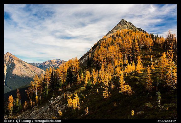
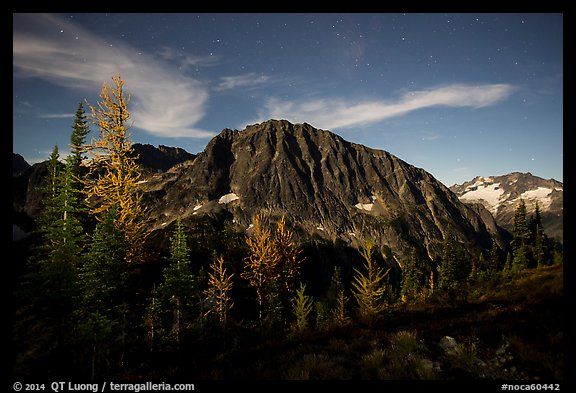
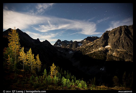
The most unique tree to the area, the subalpine larch (Larix lyallii, often called alpine larch) is a rare Pacific Northwest deciduous conifer whole needles turn bright gold before falling in mid-October. By shedding its needles each fall, the alpine larch can survive in habitats not hospitable for most other trees. Besides the northern rockies, the range of the subalpine larch is limited to a narrow band on the eastern ridge of the Cascades – coinciding with the park’s eastern boundary. The subalpine larch requires a dry climate and high elevation. To the west, the climate is too wet, whereas to the east, the elevation is too low. Places to see them in the North Cascades are all reached through trailheads along Highway 20 on its portion east of the main range. The easiest is maybe Blue Lake (4.5 mi RT, 1050 feet elevation gain), while the most popular is Maple Pass (part of the great 7.2 mile, 2000 feet gain Heather – Maple Pass Loop with beautiful views of Lake Ann). I chose instead to hike to Easy Pass (a misnomer: 7 miles RT, 2,800 feet gain) because I knew that from the pass I would be able to photograph views deep into North Cascades National Park with the subalpine larch in the background. On the loop, most of the great views are outside of the park itself.
Another reason for this choice is that I had planned create new night images at the pass. They would be possibly the first night photographs of the alpine larch photographed in the park – a Google Image search for “larch night north cascades” did not turn any night images. I would normally camp. However the park service doesn’t allow camping at the pass itself, and the nearest authorized campsite is more than 1,000 feet down on the other side at Fisher’s Creek. With no close proximity camping possible, I devised an odd plan. I would start in late morning and arrive with a few hours of daylight, then stay after dark to photograph, and return at night, aided by the full moon. Since I would be hiking down in the dark, I preferred a in-and-out hike to a loop, not only because I wouldn’t be encountering unknown terrain at night, but also because I wouldn’t miss photo opportunities on the hike.
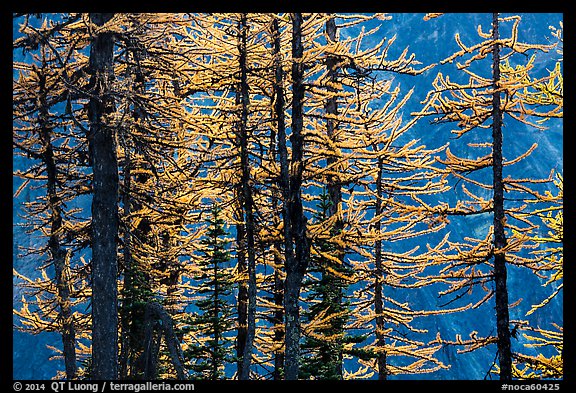
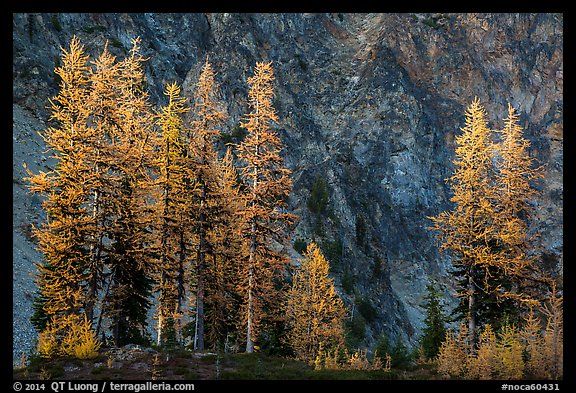
I crossed path with hikers going down. There were some good views on the trail, but by mid-day, the valley that it was following was mostly in the shade. Once I reached the pass, they became spectacular in all directions. True to what the ranger told me, the larch trees, which were mostly absent from the trail, were densely clustered on the crest. I regretted not starting earlier so that I would have had more time to explore around. Arriving at the pass in the afternoon, I photographed cross-lit trees along a slope that was just getting in the shade, and also backlit, two situations that helped emphasize the tree’s colors. After photographing wide views in all directions, I looked for close-ups of the trees and their needles. The heavy 100-400mm telephoto that I had lugged up the pass helped me isolate them against the background of a mountain face in the shade, which created contrast with its darker tone and blue tint. However, I also liked the complementary texture of a rock wall when both the trees and the wall were kissed by the last light of the day.
I normally try to avoid planning trips around the full moon, because although it is delightful for hiking and for photographing in the city, it is the least favorable time of the month for night photography of natural scenes. However I happened to be here by the full moon as I had initially hoped to photograph the lunar eclipse. It turned out that after I announced on social media that I had booked a flight for the next morning and planned to be at Shi-Shi beach next night, a few photographers pointed out to me that the eclipse was to take place on the same night, not the next night. Oops! I had a second reason for taking the trip at that time. The next few days would be my last chance of the season to visit Stehekin (more on that in the next post) and bad weather was moving in.
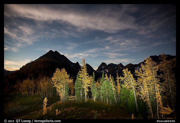
The problem with full-moon photography is that if you fully expose an image, it will look just like a daylight image, with only a few stars added to a very bright sky. To get around that challenge, the solution I have found is to underexpose and add some of the artificial light – that make moonlit city scenes work. I used a 2-stop hard edge GND (although you don’t necessary think about them then, they are also useful by night !) to reduce the sky’s brightness and illuminated the subalpine larch with a bright flashlight. Without the GND, the sky would not have a night-time appearance, especially since the numerous clouds catching moonlight were very bright. As seen on the background, without the additional illumination, the trees would be very dark and their colors lost.
I normally prefer the sharper and wider Nikon 14-24mm f/2.8 for night photography, but since it doesn’t take normal filters, I carried instead a Canon 16-35mm f/2.8. I made my first night exposures about one hour after sunset, just as the moon was rising. They required an exposure of 30s f/2.8 ISO 3200. Just one hour later, the moon was illuminating enough of the landscape that I could change to different compositions in which the mountains were more present. By that time, the exposure was reduced to 20s f/2.8 ISO 1600. After standing around at the pass for several hours at night, I was beginning to feel a bit of a chill despite wearing all my layers. Confident that I had nailed the shots (all night images are single exposure minimally processed only in Lightroom), I headed down. It turned out to be the last clear night I would see on my trip.
More photos of North Cascades National Park