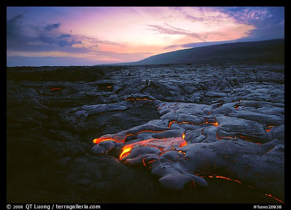
Photo spot 50: Hawaii Volcanoes National Park – Chain of Craters Road
One Comment
Hawaii Volcanoes National Park, on the Big Island of Hawaii, is the place where the past and present volcanic island activity can be observed. It is the easiest place in the world to come close to a active volcano.
The entire island was created by the Mauna Loa volcano, which now towers 13700 feet above sea level (the world highest peak on an island) and 42000 below the sea, making its total height above the ocean floor the largest of any mountain on earth.
What makes the park one of the most dynamic places on earth is the other volcano, Kilauea. It is one of the world’s most active volcanoes, erupting continuously for thirty years. Unlike other dangerous volcanoes such as Merapi in Indonesia (in the vicinity of which I had actually planned to travel in November 2010… that is until I learned about the deadly eruption), the Hawaii volcanoes do not have an explosive eruption. Instead, they spew a fluid and slow moving flow of molten lava, which makes them the most approachable of any volcanoes on earth.
Most of the relatively accessible live lava flows in the park have taken place on the coastal plain lying past the Chain of Craters Road. In fact, lava flows have buried the very end of this road, and rangers direct visitors to a makeshift parking area.
On my first visit, in January 2001, the closest flows required a hike of about 4 miles from the end of the Chains of Craters road. While this doesn’t seem that much, my fiancee and I soon found out that hiking on a recently formed hardened lava field was tough work, in the tropical heat and humidity. You hike cross-country on a very chaotic terrain with unpredictable obstacles, and lava can be very sharp !
During the day, the red glow of the lava is almost invisible. Molten lava looks a metallic grey which isn’t that different from freshly hardened lava, while old lava is more dark. By the time we got to the flow, since the hike had taken so much longer than we had planned, the night had fallen for a while. The glow of the flow was very bright in the dark, but the rest of the landscape was pitch black, which did not provide for particularly interesting images. Although it was sure heavy to lug around, I did not even bother to set up the large format camera.
On the way back, we were startled and quite frightened to notice that the red light underfoot indicated that lava was actually flowing beneath some of the spots that we had previously crossed by daylight. Where we thought that the lava had long hardened, the flow was still live beneath our feet. We made some long detours, and did not go to bed until a few hours before dawn. We decided against making another attempt on the same trip. This was supposed to be a tropical vacation !
The volcanic activity is constantly changing, so depending on timing there can be no flow at all in the park, or in the best case, the flow can form a spectacular ocean entry close to the road. For a year and half, I monitored the USGS Hawaiian Volcano Observatory website, the best place to get accurate information about the Kilauea eruption.
When I returned, in the summer of 2002, the flow was only a fifteen minute hike from the end of the Chain of Craters road, making it possible for to return multiple times to catch the best conditions at dusk and at dawn. As the lava was oozing very slowy, I was able to get close enough to feel my skin burning, and compose images with a wide-angle lens, as I witnessed the creation of a new layer of land in front of my eyes.


View more images of Hawaii Volcanoes National Park
View more images of live lava flows


I’ve been there multiple times as well to watch the lava flow and there is nothing quite like it. The creation of new earth right before your eyes – mesmerizing! Great images as always QT.